If this message is not displaying properly,
click here
to launch your browser. |

| February 2014 | Issue No. 22 |

LCBP Awards nearly $455,000 in Grants
LCBP awarded 74 grants totaling $454,900 in January. Grants were awarded through two programs, supported with EPA, Great Lakes Fishery Commission, and National Park Service funds. A total of $374,000 in Local Implementation Grants will support a diverse set of projects in four categories: Pollution Prevention, AIS Spread Prevention, Education and Outreach, and Organizational Support. Champlain Valley National Heritage Partnership (CVNHP) grants totaling $80,000 were awarded to communities and organizations in Vermont and New York.
Local Implementation Grants allow watershed organizations, schools, municipalities, research institutions, and other partners in Vermont and New York to accomplish important on-the-ground water quality and habitat protection tasks, including implementation of stormwater BMPs in urban and agricultural areas, informing the public about proper disposal of toxic substances, and control of water chestnut and other invasive species. The funds also provide support for basic operating functions such as website development and capacity to offer technical support on water quality issues.
Heritage Grants will support 21 new projects that highlight local heritage and commemorate the War of 1812 and the American Civil War. Ten commemoration projects will promote the anniversaries and support bicentennial/sesquicentennial programs and events. Eleven local heritage proposals will involve youth and students in the research and interpretation of local heritage, and the creation of new artistic expressions of local history and culture through fresh perspectives and new technology.
Since 1992, the LCBP has awarded more than $5.3 million to nearly 850 projects in New York and Vermont through competitive grant programs. Funded projects cover all actions in the Lake Champlain management plan Opportunities for Action, from phosphorus reduction, to preventing the spread of nuisance species, to public education and outreach, to restoring important cultural heritage sites. To learn more about these grants, please search our Grants Database or browse our Grants Map. Vermont Phosphorus TMDL Update
In a renewed effort to achieve water quality goals for Lake Champlain, the State of Vermont and the EPA are working together to revise the Total Maximum Daily Load (TMDL) for phosphorus inputs to Lake Champlain from the Vermont portion of the watershed. The TMDL is being established by the EPA and will be implemented at the State level.
Vermont’s most recent TMDL for Lake Champlain was approved in 2002 (New York has a similar TMDL in place). The Vermont TMDL has been undergoing a revision since 2011, and the EPA contracted with Tetra Tech to conduct lake and watershed modeling to support this revision effort. The current estimated phosphorus load for Lake Champlain (including input from Vermont, New York, and Québec) is 817 metric tons per year (533 metric tons are from Vermont alone). Based on the updated modeling results, the target load is 495 metric tons per year (343 metric tons for Vermont).
In November 2013, the State of Vermont issued a new draft implementation plan to reduce phosphorus loads. In December, the LCBP facilitated six public meetings with representatives from the State of Vermont and the EPA throughout the basin to inform the public and receive feedback. The EPA replied to the State in mid-January 2014 with a list of suggested improvements to their implementation plan and a description of an accountability framework to ensure that reductions are achieved.
Vermont will now consider the EPA’s recommendations, along with suggestions from the public, and draft a full implementation plan by March 31, 2014. The revised implementation plan is anticipated to include more detailed commitments along with implementation schedules and milestones for each action category. EPA intends to issue a draft version of key components of the TMDL (such as allocations for point and nonpoint sources) for public input by late spring, and then a final version incorporating the State’s implementation plan by late summer. Stay tuned for more updates on the TMDL revision as this project progresses.
Science Brief: Worse than Weeds? Herbicides in our Communities and Lake
Summertime bounty in the Champlain Valley often means the weeds are growing wild, too. Many farmers and homeowners turn to a quick fix: herbicides. Is it safe for our communities and the Lake? Or is it worse than weeds?
The most widely used herbicide in the United States is glyphosate, the active ingredient in Roundup and AquaPro, among others, with over 180 million pounds applied annually to home gardens and agricultural and commercial areas. It also is widely used to clear railroad tracks of weeds and to manage roadsides. Glyphosate is a non-selective herbicide and works by blocking enzymes that synthesize amino acids. In other words, it affects most actively growing plants by inhibiting growth at the sub-cellular level, because those amino acids help create proteins that would then become cell walls and other plant structures.
Monsanto first created and patented Roundup in the early 1970s and followed its immediate success with a line of patented glyphosate-resistant crop seeds, marketed as Roundup Ready®.
Globally, glyphosate has dramatically improved crop yield potential, thereby reducing hunger. The World Health Organization, the European Food Safety Agency, and the US Food and Drug Administration all classify glyphosate as non-toxic for both the environment and for people.
But several recent scientific journal articles investigated the link between glyphosate and increased cancer risk, citing evidence that chronic exposure to the pesticide may have adverse health effects, such as increased risk of non-Hodgkin’s Lymphoma, breast cancer, and other chronic diseases. Glyphosate also has been shown to have negative effects on microbial life in soils, and on fish and amphibians in water environments, causing larval die-offs, deformities, and long-term soil health degradation.
Read the full article, including literature cited and links to additional information. >> Lessons Learned from Boat Launch Steward Program
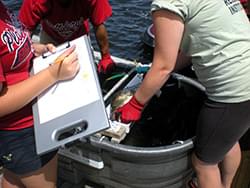
Winter is a quiet time for the boat launch stewards, but it is an ideal time for analyzing the reams of data that the LCBP collects the previous summer. Upon reviewing the data collected at fifteen boat launches on Lake Champlain between Memorial Day and Labor Day, aquatic invasive species (AIS) managers have tracked trends and drawn conclusions.
Perhaps most notable is the number of boats that were found carrying invasives such as Eurasion water milfoil, curly leaf pondweed, and zebra mussels when leaving Lake Champlain. Almost 13,000 boats were inspected while launching or departing from Lake Champlain and 325 (2.5%) were found to be transporting an aquatic invasive species. The 483 AIS specimens collected brings attention to the overland movement of AIS on recreational boats that are trailered from one body of water to another.
Preventing spread of AIS between water bodies is a primary goal of the boat launch steward program. Boats entering Lake Champlain came from as far as Texas and Colorado and included 24 states in total. The water bodies most commonly visited in the two weeks prior to launching in Lake Champlain include Candlewood Lake in Connecticut, the Hudson River, Saratoga Lake, Oneida Lake, and the Atlantic Ocean. These systems harbor AIS that currently are not known to be in Lake Champlain. It is also important to prevent the spread of AIS found in Lake Champlain to other water bodies in the region. The data showed that many of those surveyed next expected to visit water bodies in a dozen states throughout the northeast.
The encouraging news is that 76% of boaters interviewed had previous contact with a steward, and 85% of visitors had taken one or more spread prevention measures, including visual inspection and hand removal, power washing, or clean-drain-dry. AIS research indicates that visual inspection and hand removal reduced the amounts of plants on boats by 88%. High-pressure washing was most effective at removing small-bodied organisms with a 91% removal rate, and low-pressure washing and hand removal were less effective at 74% removal rates. This information will help to target future education and outreach efforts of the stewards.
LCBP’s Meg Modley presented these findings at the North American Lake Management Society annual meeting in San Diego in December. View her presentation. >> 
Grant ResultsRozalia Project The Rozalia Project, based in Granville, Vermont, used an E&O Local Implementation grant to clean up marine debris in Lake Champlain. More than 400 adult volunteers and 290 Vermont students and teachers worked with Vermont Department of Labor crews to pick up more than 500,000 pieces of trash from Lake Champlain’s shorelines. The Rozalia Project also developed public outreach materials and a comprehensive Vermont-based STEM curriculum.
Science and Technology of Underwater Discovery Curriculum
South Lake Bike Loops
Barre-Montpelier Stormwater Education Project
Lake George On-Site Rainwater Harvesting Irrigation System Demo Research and Implementation Projects
Effects of Lakeshore Development on Littoral Habitat Modeled
Under contract to LCBP, Fitzgerald Environmental, Inc. documented the impact of varying levels of human development on lake-bottom habitat in nearshore areas of Lake Champlain. The study examined 90 sites in Malletts Bay in Vermont, with the goal of extending the methodology to other areas of the Lake. The study found that that the relative influence of natural variables such as wind/wave exposure and shoreline slope were less than the extent of shoreline development. The researchers developed a GIS tool that helps to predict species richness and woody debris habitat in areas outside of Malletts Bay.
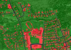
Basin Impervious Surfaces Mapped
Post Tournament Release Movements of Black Bass

Love the Lake
Save the dates! More fascinating talks and delicious desserts are on the menu this winter. All presentations begin at 6:30.
Dynamic Lake Champlain: Forecasting, Climatology and Interesting Phenomena John Goff, Senior Forecaster NOAA/NWS Burlington, VT Andrew Loconto, Meteorologist NOAA/NWS Burlington, VT
February 27: ROVs, AUVs, and Acoustic Telemetry - Studying Fish with Modern Technology Ellen Marsden, Professor of Fisheries University of Vermont
March 6: Around the Island of Montreal During the French Regime Jean Belisle, Professor Emeritus Concordia University
March 13: What Can We Learn from the 2011 Floods? Mike Winslow, Staff Scientist Lake Champlain Committee
The LCBP office is in the Gordon-Center House at 54 West Shore Road in Grand Isle, Vermont—just a short walk from the LCT ferry. ALL EVENTS ARE FREE.
World Water Day CelebrationCBEI Teacher Workshop/Student Competition
March 21
This will be followed by a separate event from 4-7 p.m. featuring a student competition about World Water with prizes to be awarded. Our special guest speaker will be Lisa Borre, a lake conservationist, freelance writer, and avid sailor. Lisa is a regular contributor to National Geographic's Water Currents blog and an active member of the Global Lake Ecological Observatory Network.With her husband, she co-founded LakeNet, a world lakes network. Lisa was the Vermont coordinator of the Lake Champlain Basin Program from 1990 to 1997.
More detailed information will be available later this month. Conferences
38th Annual Meeting of the New England Association of Environmental Biologists (NEAEB)
25th Annual Nonpoint Source Pollution Conference |


 The Lake Champlain Basin Program (LCBP) works in partnership with government agencies from New York, Vermont, and Quebec, private organizations, local communities, and individuals to coordinate and fund efforts which benefit the Lake Champlain Basin’s water quality, fisheries, wetlands, wildlife, recreation, and cultural resources.
Learn more or view our Management Plan. The Lake Champlain Basin Program (LCBP) works in partnership with government agencies from New York, Vermont, and Quebec, private organizations, local communities, and individuals to coordinate and fund efforts which benefit the Lake Champlain Basin’s water quality, fisheries, wetlands, wildlife, recreation, and cultural resources.
Learn more or view our Management Plan. |
 Opportunities for Action Opportunities for ActionState of the Lake Basin Atlas WatershED Matters Lawn to Lake |
 E-newsletter |
| Lake Champlain Basin Program 54 West Shore Road Grand Isle, VT 05458 800/468-5227 (NY & VT) or 802/372-3213 |
© 2012 Lake Champlain Basin Program |
If you’d like to stop receiving the Casin' in the Basin newsletter,
unsubscribe.
|