A new interactive mapping tool to steer wetland and riparian management in the New York portion of the Lake Champlain Basin
Project summary
Over a 2-year study, a team of researchers at the New York Natural Heritage Program developed a series of field-validated models to estimate stream water quality, assess the opportunity for wetlands to desynchronize flood water pulses, and evaluate wetland connectivity to floodplains and surface waters across the New York portion of the Lake Champlain Basin. These tools will support wetland and riparian management to improve flood mitigation, water quality, and habitat for native species. The resulting interactive mapping tool offers accessible, synthesized information that can be used by natural resource managers to prioritize conservation and restoration efforts.
Key results
Key project outputs include:
- A data layer that demonstrates predicted stream water quality based on previously-collected and field-validated stream macroinvertebrate data.
- A data layer that depicts wetland complexes (adjacent wetland types merged to make a single analysis unit) and field-validated predicted ecological condition of each complex.
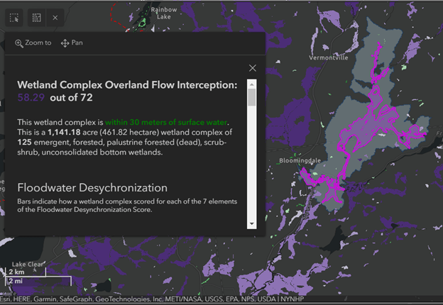
- A ranking system to assess the potential of wetland complexes to absorb and slow surface water flows from precipitation events (wetland complex overland flow interception score). Wetlands that are larger, contain multiple habitat types, have higher canopy cover, and sit within catchments with more natural and wetland cover and less crop and impervious surface cover are ranked more highly in this system.
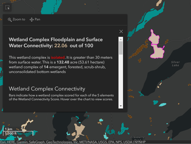
- A ranking system assessing the ability of wetland complexes to receive over-bank floodwaters and decrease downstream flooding (wetland complex floodplain and surface water connectivity score). Wetlands that are closer to surface water bodies, have no barriers between the wetland and streams, are located within riparian area, and located in core floodplain areas are ranked more highly in this system.
- A map of the boundaries for all land uphill of each wetland (the wetland catchment) and a suite of habitat metrics calculated for each wetland.
- An interactive mapping tool for natural resource managers and members of the public can be used to access the findings from this project. Users can apply filters for wetland size, floodwater desynchronization score, and connectivity score to highlight wetlands relevant to their interests.
Other Takeaways
- Similar tools for resource managers highlighting areas benefitting clean water and conservation goals were previously available for only the Vermont portion of the Lake Champlain Basin; this project resulted in the creation of similar tools for the New York side of the Lake Champlain Basin.
- These tools enable users to identify high-performing wetlands that could be prioritized for conservation, and lower-performing wetlands that could be prioritized for restoration.
Read the full technical report, including best-practices for using the interactive map, at this link.
The project webpage is available here.