Lake Champlain Floods of 2011

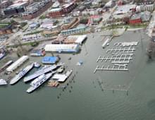
In 2011, two major flooding events affected the Lake Champlain Basin. Record snowmelt and heavy spring rains brought Lake Champlain to flood stage (100 feet above mean sea level) on April 13, 2011. The lake level remained above this level for 67 days until June 19, 2011. A new record was set on May 6, 2011, when Lake Champlain crested at 103.27 feet. Just a few months later, on August 28, 2011, Tropical Storm Irene swept through the region bringing significant rainfall to the southern segments of the Champlain basin.
The flood events of 2011 had a profound and lasting impact on the watersheds of Lake Champlain and the Richelieu River Valley and their residents. During the spring floods, high water levels and wind-driven waves battered the Lake shoreline, inundating lakeshore houses and other low-lying structures and eroding vast amounts of shoreline sediments. Communities along the Richelieu River—the Lake’s drainage to the north— suffered similarly during prolonged flooding over the two-month period. Flooding impacts from Irene were felt most acutely in the tributaries in the southern sector of the Basin, where surging streams devastated both infrastructure and personal property in many areas. As with the spring floods, tributary floodwaters again delivered large sediment and nutrient loads to the Lake.
These events triggered a good deal of thoughtful consideration throughout the region of the causes and effects of flooding, as well as the need to mitigate the impact of future flood events by achieving greater flood resilience in the Basin. To this end, the LCBP convened a series of flood resilience conferences to examine the issues in the Basin. This conference resulted in a collaborative Flood Resilience report that summarizes the findings and identifies potential ways to prepare for the next flood.
More on the 2011 flooding in the Lake Champlain Basin
- Powerpoint presentation, The Floods of 2011 – A Quick View (34MB)
- Spring Flooding Photo Gallery (also viewable in a Google Map)
- Tropical Storm Irene Photo Gallery
- Satellite Imagery of Lake Champlain flood conditions (April 8 – May 12).