July 2023 Flooding
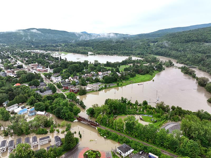
On July 10, 2023, a slow-moving storm brought seven inches of rain or more to parts of our region, causing major flooding in the Lake Champlain Basin. The immediate impact of this event was primarily in our rivers and the communities they run through, where high waters caused widespread property damage, infrastructure failure, crop loss, and family displacement. As the Lake Champlain watershed was inundated with heavy rainfall, more than ten thousand miles of streams and rivers rose quickly, sending water downstream toward larger tributaries, and eventually the lake. As flood waters in these communities receded, this flush of water, sediment, nutrients, and pollutants flowed downstream to Lake Champlain.
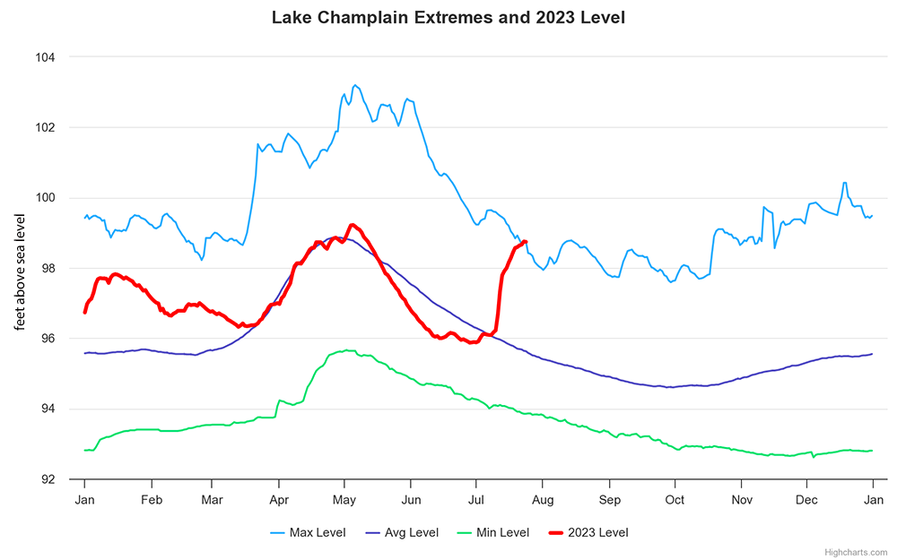
At peak flow following the rainfall, our rivers in Vermont, New York, and Québec sent nearly 4 billion gallons of water to Lake Champlain every hour. As a result of these inputs, Lake Champlain level rose about three feet over its 435 square mile area. This brought its elevation back to a typical level for the spring season, but an unusually high level for the summer season. On July 23, the lake reached its highest elevation ever recorded for that date.
The large amounts of sediment delivered to the lake by this storm mixed with lake water and led to a substantial decrease in water clarity. Decreased water clarity can have impacts on phytoplankton growing in the lake, which forms the base of the food web. It can also lead to a reduction in dissolved oxygen levels and decreased visibility for fish hunting for prey. These impacts are expected to decrease within a few weeks; as of July 26, lake water clarity is near normal levels, though rivers are still running high with additional sediment being delivered.
Storms have a much greater influence on river and lake water quality and ecosystem health compared to times of low water flow. These times of high flow are when most water, sediment, and pollutants are delivered to the lake. For our major rivers in the Lake Champlain Basin, the day with the highest flow will typically deliver 5-10% of the phosphorus for that entire year. A major storm like the July 2023 flood highlights the importance of these storms for water quality and can send as much phosphorus downstream as an entire typical year. For example, for the week starting on July 10, the Lamoille River delivered more phosphorus to Lake Champlain than in all of 2022.
The nutrients delivered by this storm will combine with many other factors to influence water quality in Lake Champlain. In the short term, the decreased water clarity will likely limit light available for phytoplankton (including cyanobacteria) to create energy and grow. In the longer term, it is possible that the increased nutrient inputs could fuel cyanobacteria growth in some areas of the lake later this season and beyond. In other areas of the lake, storm inputs may not be as influential on cyanobacteria growth this season because phosphorus availability is primarily driven by internal lake processes and legacy phosphorus release from lake-bottom sediments.
Historically, Burlington and other communities in the region sent untreated sewage into Lake Champlain as a general practice until the 1950s. Although we have come a very long way since then in treating our wastewater and reducing pollution to Lake Champlain, the July 2023 flooding highlighted the vulnerability of our stormwater and wastewater systems. Flooding and stormwater runoff caused several wastewater treatment infrastructure failures and led to combined sewer overflows in the watershed that each delivered untreated wastewater to Lake Champlain. For example, a sewer pipe that runs underneath the Winooski River in Burlington was damaged by high flows, and the Johnson wastewater treatment facility suffered catastrophic damage.
The wastewater that entered our rivers and Lake Champlain because of this damage is dilute effluent that includes everything that goes down the drains of homes and businesses. Although the amount of dilute wastewater discharged was a small fraction of total storm flows, there is the possibility for pathogenic (illness-causing) bacteria or viruses to be present in lake water immediately following flood inputs. Most beach managers test for bacteria regularly and many currently show safe conditions for swimming. The LCBP swimming webpage provides general information about swimming safety, and the cities, towns, and parks that operate beaches are the best source for up-to-date water quality information.
Oil spills can have devastating impacts to freshwater ecosystems and should be prevented wherever possible. Vermont Department of Environmental Conservation tracked several oil and chemical spills because of the July 2023 flooding. Many of these are from basement storage tanks or other areas that were inundated with water. Because these spills were relatively minor in the context of stormflows, short-term or lasting impacts are not expected for Lake Champlain or the ecosystem, though there may be local impacts where contaminants were deposited. LCBP and our partners are working to prepare for the potential of a more major oil or chemical spill through Environmental Sensitivity Mapping, which will create tools and resources for response teams to react swiftly in the event of a major spill incident on Lake Champlain.
This storm demonstrated the incredible value of science and informed decision-making for the Lake Champlain Basin. Water volume monitoring at 22 of our major tributaries provided data for federal agencies to forecast how high our rivers would go during the flood, providing in-the-moment preparedness information for our communities and emergency responders. Buoys on the Lamoille River and in Malletts Bay monitored water quality every 15 minutes throughout the flood, providing critical information on what went downstream and when, so we can learn more about the impacts of flooding and target our restoration efforts. LCBP and our partners continue to support research and on-the-ground implementation for flood resilience and mitigation. The 2024 Lake Champlain State of the Lake and Ecosystem Indicators report will feature detailed information on the effects of this event and lessons to increase flood resilience in the future.