U.S. Geological Survey New England Water Science Center
Mission
The U.S. Geological Survey (USGS) serves the Nation by providing science about the natural hazards that threaten lives and livelihoods; the water, energy, minerals, and other natural resources we rely on; the health of our ecosystems and environment; and the impacts of climate and land-use change. In the Lake Champlain Basin, the USGS New England Water Science conducts interdisciplinary science to address water quality and water quantity issues that affect the natural resources.
Agency Initiatives
Lake Champlain Basin River Flows / Flood events
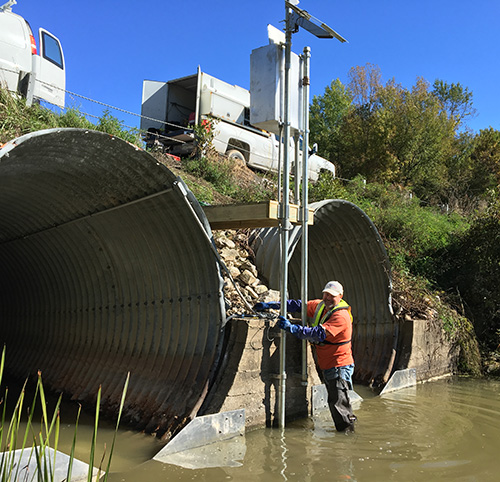
USGS operates 43 streamflow gages and 5 lake level gages that are used to continuously measure the amount and height of water in streams and rivers, and the height of Lake Champlain. The information collected at these gages is posted in near real-time at waterdata.usgs.gov. These data are used for flood warning and forecasting, estimating the amount of nutrients and sediment entering Lake Champlain from tributaries, hydropower operations, drought monitoring and forecasting, hydrologic research, fisheries management, and recreational water activities such as boating. The USGS operates the gages in cooperation with the States of New York and Vermont, numerous local governments, hydropower and dam operators, the US Department of Agriculture Conservation Effect Assessment Program, and the International Joint Commission.
Flood forecasting and mitigation
Flood-inundation maps depict estimates of the areal extent of flooding corresponding to selected water-surface elevations (stages) at the USGS lake gages on Lake Champlain. Updated digital elevation models (DEMs) were created from lidar data for Lake Champlain in Vermont and New York. These DEMs were used in determining the flood-inundation boundary and associated depth grids for 11 flood stages at 0.5-ft or 1-ft intervals from 100.0 to 106.0 ft (NGVD 29) as referenced to the USGS lake gages.
Current Projects
Vermont street sweeping and nutrient reductions
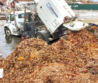
Leaf litter on paved and developed surfaces can contribute as much as 70 to 80 percent of the total phosphorus load to urban waters during non- winter periods. The USGS is evaluating the potential reductions in nutrient and sediment loads through analysis of the source areas and land-use types, physical and chemical analysis of municipal solids, and using these data to develop a numerical model examining load reductions using street cleaning and leaf removal programs.
Other Federal Agencies Involved: U.S. Environmental Protection Agency
Learn more about Nutrient and Sediment Load Reduction Estimates from Intensive Street Cleaning and Leaf Litter Removal
First Floor elevation of buildings around Lake Champlain
The work will involve two equipment operators running independent surveys (one performing daily Level II GNSS campaigns tor survey control; the other operating “reflectorless” total station surveying equipment) in select neighborhoods around the Lake Champlain. The GNSS operation will set the elevation control reference marks (RMs). The total station operator will then occupy those RMs with the reflectorless equipment to remotely measure first floor thresholds.
Other Federal Agencies Involved: International Joint Commission