USDA Forest Service Eastern Region
Mission
In the Lake Champlain watershed, both the Green Mountain National Forest and State and Private Forestry work with state agencies and private landowners to improve and maintain water quality through better managed forests for the American people. We collaborate with others to enhance stream health, establish riparian buffers, provide source water protection, and reduce storm water runoff and other non-point sources of pollution.
Agency Initiatives
Green Mountain National Forest
The Green Mountain National Forest (GMNF) encompasses more than 400,000 acres in southwestern and central Vermont, forming the largest contiguous public land area in the state. We monitor the condition of soil and water resources on the Green Mountain National Forest to determine if they are in a healthy condition. Ecosystem services provided by these resources include carbon storage and cycling, ground water recharge, biotic habitats, and flood mitigation. The GMNF provides ecological and science-based forestry stewardship, clean water, diverse vegetation, high-value, high-quality forest products, eight wilderness areas, economic and educational contributions, and trail-based backcountry recreation.
State and Private Forestry
State and Private Forestry collaborates with states, other federal agencies, tribes, private landowners, and other partners to protect, conserve, and manage forests and community trees across the 20 Northeastern and Midwestern States and the District of Columbia. We provide leadership, technical support, sound science, and financial assistance, to help ensure that our forests and trees continue to provide clean water, forest products, wildlife habitat, recreation, and other benefits for present and future generations.
Current Projects
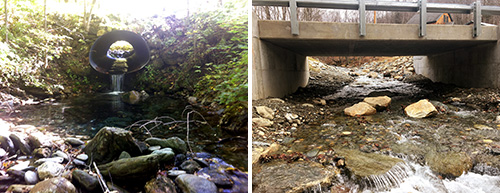
Mettawee Aquatic Organism Passage Project
Federal and State Agencies and NGO’s collaborated on the identification and removal of seven barrier to aquatic organism in the headwaters of the Mettawee River. As of 2019 3 barriers have been removed and 4 others are under design and permitting. When complete, the project will create 23 miles of contiguous cold water habitat.
Other Federal Agencies Involved: NRCS, USFWS
Learn more about the Joint Chiefs’ Landscape Restoration Partnership
Bridges Reducing Timber Harvesting Water Impacts
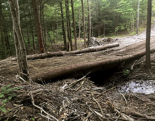
The State of Vermont used a Forest Service Landscape Scale Restoration grant along with matching funds to reduce non-point pollution from timber operations from 2014 to 2019. The State’s plan set out to coordinate training and share resources and best management practices with loggers and foresters about improved stream-crossing practices.