Quantifying the de-icing salt pollution load to Mirror Lake and the Chubb River
Project summary
The pollutant load from de-icing salts into waterways of the Lake Champlain Basin (LCB) has increased significantly over the past few decades, causing increasing concerns over salinization. Salinization impacts are most pronounced in areas with dense urban development where runoff from roads, parking lots, sidewalks, and driveways can contain high concentrations of salt.
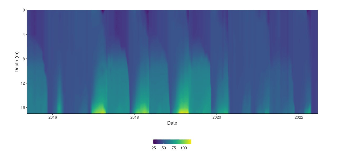
Mirror Lake and the Chubb River, located in the headwaters of the West Branch Ausable River subwatershed, are impacted by de-icing salt application in their watersheds. Direct stormwater discharge to Mirror has resulted in a reduction in spring mixing due to salt-induced density differences within the water column.
From 2019 to 2022, Lake Champlain Basin Program partnered with Ausable Freshwater Center and Paul Smith’s College Adirondack Watershed Institute to 1) establish a continuous water quality monitoring program to quantify de-icing salt pollutant load to Mirror Lake and the Chubb River, 2) estimate the de-icing salt pollutant load to Mirror Lake from direct stormwater runoff, 3) estimate the total amount of de-icing salt applied within the Chubb River watershed, and 4) educate the public about the effects of de-icing salt on the environment and BMPs for de-icing salt reduction.

Monitoring stations with water level, temperature, and conductivity loggers continuously collected data in the Chubb River sub-watershed and at the inlet and outlet of Mirror Lake. Three sites that were unimpacted by de-icing salts also were monitored to distinguish the chloride load that was attributable to human or natural sources. In addition, salt application tracking devices were installed on the town and village road de-icing salt trucks to monitor how much road de-icing salt was applied in the region.
Key results
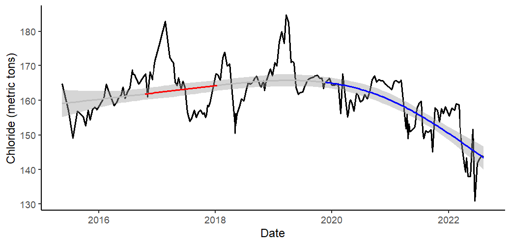
- Over 1,000 metric tons of chloride per year exported from the Chubb River subwatershed was attributable to human sources, primarily road deicing salt.
- For Mirror Lake, approximately 90 metric tons of chloride from human sources were exported annually.
- Municipal salt tracking data indicated that approximately 15-16% of the road salt was attributable to application on local roads, 33-35% from state roads, 3-4% from sidewalks, and 42-49% was unaccounted for (presumably from untracked commercial and private sources).
- Best practices for de-icing salt application have resulted in improvements for Mirror Lake water quality. A decline in the retention of chloride was measured beginning in the 2019-20 winter and continuing through the field seasons of this study. This coincided with an overall reduction in chloride concentrations measured on the lake bottom during the same period. Additionally, the lake completely turned over in the springs of 2020 and 2022, which had not occurred since 2016.
Other takeaways
- The public survey of business owners showed that methods of de-icing and targeted level of service varied greatly among respondents.
- As part of the education and outreach component of this project, interpretive signs were installed along the Mirror Lake shoreline to inform visitors on the aquatic food web, the watershed, and impacts of de-icing salt application.
- Monitoring at Mirror Lake has continued past the duration of this study to document the benefits of stormwater system improvements.